The Mil Rios ride is a true classic. The Mil Rios trail can be ridden in and of itself, using a shuttle to reach the trailhead not far from the village of La Neveria. It can also be tackled as part of a long and demanding loop ride passing through Teotitlan del Valle and Benito Juárez to get to the trailhead – as shown in the map below. Riders will struggle to climb 4778 feet (1456 meters), but get to cruise down 4586 feet (1398 meters) on the way home. Caution: the Mil Rios trail is steep and rocky in many places, so good bike handling skills are necessary.
Category: GPS
Countryside, GPS, MTBing, Photos
Santo Tomas Mazaltepec Loop Ride
by Larry • • 0 Comments
Cyclists looking for a pleasant ride through the Etla Valley west and north of Monte Alban should consider this route, which features a nice mix of paved and gravel roads and some good hill climbs. This outing is rated moderate to difficult on account of the length and some serious uphill segments. The round trip distance amounts to 38.4 miles (62 kms) with a vertical gain of 1035 feet (315 meters) going over the ridge of hills separating San Felipe Tejalápam and Santo Tomas Mazaltepec. Highest point on the trail: 6111 feet (1863 meters). The scenery along the way makes the effort worthwhile, though. Total ride time should be about six hours, including a thirty-minute lunch stop.

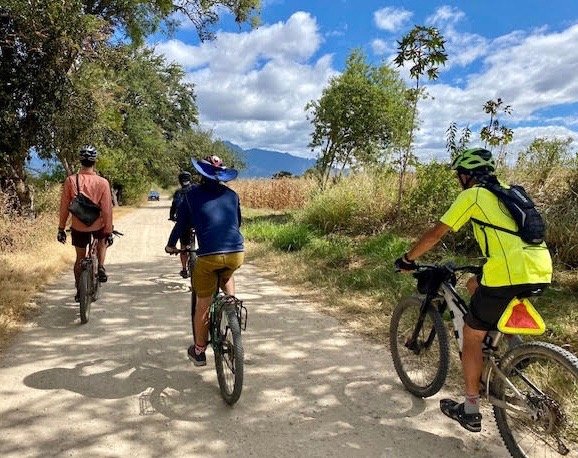


Countryside, Foothills, GPS, MTBing, Photos
Another Grand Loop Ride
by Larry • • 0 Comments
It is mid-November and the weather in Oaxaca continues to be ideal for mountain biking. The thermometer registered 54ºF / 12ºC at sunrise, with a forecast high of 81ºF / 27ºC for the day. The morning boasted clear blue skies, but clouds built up by mid-day, though with no threat of rain. A biker who is a relative newcomer to Oaxaca proposed riding a long and rather challenging loop south out of town through San Bartolo Coyotepec, then across a mountain ridge to San Sebastian Teitipac in the Tlacolula valley to the east. From there the way home would loop through Rojas de Cuauhtemoc and Tule. Four fellows met at the appointed place and began the ride at 9 am. It took an hour to pedal to San Bartolo, using mainly country roads. Then the climb began. The trail was a rough jeep road that ascends 925 vertical feet (282 meters) to a pass crossing the ridge of hills. The riders spent 1.5 hours getting from San Bartolo to San Sebastian Teitipac. From there it was an easy ride on mainly paved roads to Tule and thence back to Oaxaca on the bike path. While riding through San Sebastian our cyclists encountered ten members of the Chalinos bike club from Rojas de Cuauhtemoc who were also enjoying a Sunday ride. They were an impressive sight, as all wore matching uniforms. It was early afternoon by the time the group reached Tule, so it was decided to stop for lunch at a seafood restaurant there. Some cold beer and ceviche really hit the spot! Here are the stats for the day’s outing. Distance ridden: 35.9 miles / 57.8 kms. Total elevation gain and loss on the circuit: 1524 feet / 464 meters. Low point on the loop: 4959 feet / 1511 meters. Highest point: 5891 feet / 1796 meters. Total elapsed time (including lunch break): 5.5 hours. Rating: difficult because of length of ride and roughness of uphill sections on jeep road.


Countryside, Foothills, GPS, MTBing, Photos
Ride on the Los Molinos Trail
by Larry • • 1 Comment
It is a good bet that some fellows will get together for a weekday ride every Tuesday morning. A flurry of emails usually precedes the outing as people are informed of the ride parameters and sign up for the excursion. Cyclists congregate in front of the church in San Felipe del Aqua at 8:45 am prior to a 9 o’clock departure. Most days the group rides the network of trails in the hills above San Felipe. This affords everyone an opportunity for some serious exercise but does not eat up too much time, as the ride is finished by 11:30 or 12:00 noon. On this particular Tuesday in early November, though, the riders opted for something different. Ron, Larry and Steve rode east on the hillside above San Luis Beltran and Donaji, first on the Libramiento Norte and then on a great single track trail that winds along the contours of the mountain and terminates in Huayapam. After stopping at a juice stand in the local mercado there for some liquid refreshment, they continued through town to the two presas, then pedaled on to the start of the Los Molinos trail in Tlalixtac. This lovely trail is a perennial favorite of hikers and mountain bikers alike. It was a glorious day for a ride in the countryside, with bright sunshine and a forecast high temperature of 84ºF / 29ºC. After posing for a photo at the ruins of the old water-powered grain mill, the three headed back to Oaxaca using a combination of country roads rather then returning on the foothills trail. Once arrived back in San Felipe they stopped for a tasty lunch at the Mónica Hindu restaurant. The day’s excursion covered 20.1 miles (32.3 kms) and encompassed an elevation gain and loss of 2101 feet (640 meters) along the way. The high point was 5802 feet (1768 meters) on the Libramiento above San Felipe. Time in the saddle amounted to 4 hours and 25 minutes. The second map, below, shows just the Los Molinos trail itself.


Countryside, GPS, MTBing, Photos
Sunday Ride In The Zimatlan Valley
by Larry • • 0 Comments
Mexico switched from daylight savings to standard time overnight, so although our group ride started at the same time by the clock, the day was an hour older. That gave people more time to get going and the sun longer to burn off the morning chill. Seven fellows showed up at the rendezvous point for a pleasant ride into the Zimatlan valley to the south of Oaxaca city. Our original destination was the village of Santa Ana Zegache, where flowers are grown for the Day of the Dead festivities. We thought we would find lots of color in the farm fields thereabouts. It was a gorgeous day to be out on a bike. However, we did not find as many fields of flowers as we expected and we did not quite make it all the way to Zegache. Instead, we were content to turn around at the gigantic figure of a danzante which stands atop a hill overlooking Zimatlan, 4.5 miles short of Zegache. The group stopped for lunch and cold drinks at a convenient curb-side comedor coming back into the city. Here are the stats for the day’s outing: Round trip distance – 33.3 miles / 53.6 kms Elevation gain and loss enroute – 840 feet / 256 meters Elapsed time – just under five hours.


