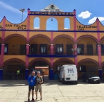
Albi and Larry are both mountain bike enthusiasts and sponsors of a program of weekly hikes around the Valley of Oaxaca and in the surrounding mountains (see www.HoofingItInOaxaca.com). They are always interested in finding new places to take groups of hikers. Many of the hike venues utilized each year were first explored aboard mountain bikes. Such was the case for a proposed new hike from the town center of San Tomas Mazaltepec to San Felipe Tejelápam. The purpose of today’s ride was to map the hike route and find out from local officials what permissions and/or payments were needed before bringing van loads of gringo tourists to hike in this part of the Etla Valley north of the city of Oaxaca. The day’s excursion got under way at 10 am, allowing the sun to warm things up on a mid-winter day. Larry and Albi were joined by Ron and Rafa for the outing. Moving at a leisurely pace, the foursome covered 30.9 miles (49.7 kms) and gained and lost 1774 feet (541 meters) in elevation on what amounted to an out & back ride with a lolly-pop loop at the far end. It was along that loop that the hike route was mapped out. It turns out the new hike will run 5.7 miles (9.2 kms). The highest point along the route tops out at 6097 feet (1858 meters), with the lowest part registering 5418 feet (1651 meters). Hike participants will climb 682 feet (208 meters) and descend 731 feet (223 meters) in the course of their walk.


